Dangerous roads in India are called the “Highway to Hell”
Road trips are considered the new fancy among travelers, especially in India. Biking along up and down the roads with friends is the next goal. Then they don't remember to care about the unseemly weather situations or the dangerous terrains. Roads, though claimed to be the best means of transportation in the world, are not always too suitable. India, for one, has a nice stock of such roads in the kitty!
Though India is already known for its horrible conditions of roads, there are some of the scariest, which can give chills to even the most trained driver. Their thin roads, steep turns, and low-hanging cliffs can lead anyone to the toughest adventure of life. These dangerous roads in India are called the “Highway to Hell” as they are built in the regions that experience the wrath of nature more often and can take you to your deathbed rather than your destination. Go, checkout as we bring you the scariest roads in India so that only some daring travelers might feel such drives as ‘perfect’ for the element of thrill.
Khardung La Pass
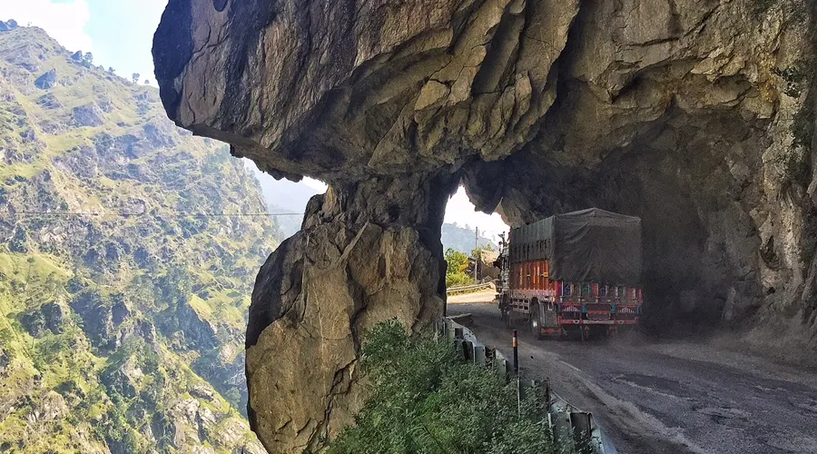
Placing this at the first position on our list has two reasons. Not only is this Pass the most difficult route to cover, but is also the highest drivable road in India. This route stretches from Leh region in Jammu & Kashmir state in India to Kashgar in China.
Khardung La, also known as Khardzong La, serves as the gateway to Shyok and Nubra Valley. Khardung La is popular as the highest motorable road in India at an elevation of 5602 meters. However, contrary to the belief, its actual elevation is 5359 metres making Dungri La the highest motorable road pass in India.
Khardung La Pass is a perfect getaway for adventure enthusiasts, peace seekers, and mountain biking aficionados. An Inner Line Permit is required by the tourists to enter the pass and travel through it. Due to heavy rains and snowfall, the Khardung La Pass remains closed from October to May.
Khardung La was built in 1976 and was opened to the public in 1988. The pass is very important for India as it is used to carry supplies to the Siachen glacier. From the top, you can get picturesque views of the Karakoram range and the Himalayas.
Chang La Pass
Gateway to the Changthang plateau in the Himalayan region is located at a height of 5360 meters. It is the third-highest drivable Pass in India which is laden with snow throughout the year. A large number of incidents of choking due to breathlessness have been reported at Chang La Pass.
At an altitude of 5,360 m above sea level, the road remains snow-covered all through the year. This makes the road very slippery. Also, one can feel the deficiency of oxygen while on this road. The low temperatures in this region add to the travel issues of those commuting through this third-highest motorable road in the world. Being a gateway to the Changthang plateau in the Himalayan region, it is one of the most thrilling roads in India.
Spiti Valley
Long winding roads and valleys that present unforgettable glimpses of cold desert and snow-crowned mountains welcome you when you set foot into Spiti Valley. Bordered on all sides by the Himalayas, Spiti Valley, located in Himachal Pradesh, has an altitude of 12,500 feet above sea level, and gets just around 250 days of sunshine in the year, making it one of the coldest places in the country.
The term Spiti means 'The Middle Land', as Spiti Valley separates India from Tibet. True to its name, Spiti is home to several monasteries. Notably, the stunning Key Monastery is over a thousand years old and is also the largest monastery to be found in the entire Spiti Valley.
Scantily populated, Spiti is an adventure lover’s paradise, with a number of trekking trails and mountain passes that tourists can choose from. Kunzum La offers an incredible 360-degree view of Bara-Shigri Glacier (the second-longest glacier in the world). All of these treks start from Kaza to various peaks from where you can get panoramic views of the Himalayan mountains.
An easy 1.5-kilometer trek along the Spiti River from Dhankar Monastery to Dhankar Lake promises gorgeous views of the villages below. The Dhankar Lake itself is a place where you can sit back and relax amidst the cool mountain air. Another mystical site to visit is Chandratal Lake, where the water keeps changing from reddish to orange to blue to emerald green as the day ends. With the thick Himalayan snow cutting Spiti off from the rest of the country for around 6 months a year, the summer months are the only time Spiti is directly accessible via motorway.
Situated in Himachal Pradesh, Spiti Valley is one of the scariest roads in India for all adventure seekers. The mesmerizing landscape and harsh weather conditions around the jaw-dropping turns make it all the more beautiful and difficult to resist going and trying to get the adrenaline rush. Apart from this, the valley also houses the most remote and highest villages in the world.
Zoji La Pass
This path is located on the Leh-Srinagar Highway at an elevation of 3538 meters. The main reason for it to be listed as one of the most dangerous roads in India is the extreme weather conditions throughout the year. Heavy rains and sudden landslides turn the road into a muddy path which is an invitation to fatal accidents.
In the blink of an eye, the vehicle can land you down from an altitude of 3,538. Zoji La Pass is one of the country's most feared roads as it is frightfully narrow and covered in snow slush all around the season. You will come across this route while you are making your route to Leh from Srinagar. The pass is a major connection between Ladakh and Kashmir.
Kinnaur Road
Kinnaur Road is another beautiful drive with a great not-even-hidden danger. The road is made by cutting the edge of the mountains on the top of the Baspa River, which is so low, that sometimes you have to peep to see the flowing water. This road connects the Kinnaur District in Himachal Pradesh to the rest of the country. With a high altitude of around 4000 meters, this is another getaway for adventure lovers.
One of the twelve districts of Himachal Pradesh, Kinnaur is located on the Indo-Tibet border. Situated at a distance of 235 km from Shimla, Kinnaur hosts the views of Zanskar Valley, snow-draped Dhauladar range, Chitkul - The last village on the Indo-Tibet border, and Satluj, Baspa, and Spiti rivers meandering through it.
Also known as the "Land of God", the most important attraction of the Kinnaur district is the religious "Shiva Lingam", the representation of Lord Shiva and the mesmerising rock formations change their colours several times during the day. There are old Buddhist monasteries and temples in the vicinity which hold particular importance and are revered by Buddhists.
Apart from religion, Kinnaur also has a vast scope in adventure sports like trekking and skiing. There are about nine known routes for trekking some of which are five-day or six-day trips. Kinnaur is well known for its delicious apples, Chilgoza, handlooms, and handicrafts materials. The valleys of Kinnaur are also some of the most sought-after camping destinations in India, like Sangla Valley. Apple orchard camps and camping on the rivers Baspa and Satluj are some of the scenic destinations to pitch your tents for an amazing camping experience.
The road is located in the southwest of Himachal Pradesh and will scare you with its cliff-hanging drives and deep narrow holes. One mistake and you will be gone. This valley remains closed during heavy snowfall. Be careful while travelling through Taranda Dhank which is also famous for claiming lives.
Rohtang Pass
Situated at a height of 3979 meters on the eastern Pir Panjal Range of the Himalayas, this Pass is one of the most scenic beauties in Manali, Himachal Pradesh. It is traversed by Leh Manali Highway and also forms a great attraction among tourists, courtesy of the shooting of many Bollywood films.
Located at a distance of just 51 kilometers from Manali, Rohtang Pass can be reached only by road. The pass is located at a massive height of 3978 meters on the Manali- Keylong road. When planning a trip to Manali, a day off to the vista point of Rohtang Pass is the ultimate and almost essential attraction of the itinerary.
Owing to its splendid natural beauty, Rohtang Pass is a favorite among the community of film directors. Many blockbusters ranging from 'Jab We Met' to 'Yeh Jawani Hai Deewani' have been shot here. A peculiar fact behind the name of the place is that it was named so because a number of people working in CBRE died whilst trying to cross this treacherous stretch.
An experience of the snow can never be complete without a sled ride, which involves sliding through the snow in a wooden toboggan. Another thrilling activity that can be pursued at Rohtang Pass would be mountain biking where you ride your mountain bikes off the regular course and into the lesser taken routes. It can get a bit rough, so you must take care in case you are planning on pursuing this activity.
You can try your hand at skiing and tire drop at the Rohtang Pass as well, where again you slide down a slope of snow whilst using the appropriate equipment. Gear for all of these activities is available for reasonable rent, so do not miss out on this opportunity.
This path is the ground of corpses as the name suggests. It connects Kullu with the valleys of Lahaul and Spiti. This path faces huge traffic jams when it is usually open from May to November. The path gets closed for an infinite time due to heavy snowfall with continuous sliding of hills and rain, the road gets covered with sludge.
Leh Manali Highway
Topping the list of to-do road trips among youngsters in India is biking from Manali in Himachal Pradesh to Leh in Jammu & Kashmir. Spanning over a distance of 479 km, this road gives you the journey of your dreams. Landscape awe-inspiring and experience surreal- this is the review of the travelers. But some reviews also include the harsh realities of poor weather and pathetic road conditions in some places. This Dangerous Road in India is totally worth the adventure!
This place is the deadliest, the low overhanging rocks, narrow dark holes, and blind turns make this road highly deadly. One fault and the vehicle will drop down into the Baspa River. If not the fall, the collision of vehicles around the blind turns is truly deadly.
Nathu La Pass
Like other high roads in India, this road is no different in rendering a life of adventure and horror, both at the same time. Nathu La Pass is located on the border of India and China and forms one of the three trade links between the two countries, because of which heavy-loaded trucks are not a rare phenomenon. Access to the Pass is also not easy because of too much snow.
Nathula, one of the highest motorable roads in the world, is a mountain pass in the Himalayan peaks that co-joins Sikkim and China. Situated on the Indo-Tibetan border 14450 ft. above sea level, Nathu La is one of the most important Himalayan passes in the country. Nathu means 'listening ears', and La means 'pass'. Nathula is one of the three open trading border posts between India and China and is famous for its picturesque beauty and beautiful environment. The temperature here remains low for most parts of the year, and it becomes a hotspot for tourists during summer.
Several tourists flock here every year for trekking in the valley and enjoying the scenic beauty. There are a number of waterfalls that gush along the way from Gangtok to Nathu La. It also offers an opportunity to see beautiful snow peaks encircling the area. The region also supports Himalayan wildlife like Tibetan gazelle, snow leopard, yaks, Tibetan wolves, etc. Nathu La Pass has a rich variety of flora apart from a spectacular wildlife range.
It is one of the three trade border posts connecting China and India and is situated 54 km east of Gangtok. The pass is 4,310 Meters above sea level and is one of the highest passes reachable via road. The path becomes very deadly because of the massive landslides and heavy snowfall during winter.
Munnar Road
Starting from Kochi and ending at Munnar, this 130 km stretch is located on the Western Ghats of India. One of the most renowned hill stations in South India, Munnar is situated at an elevation of 1700 meters. But reaching Munnar is a fun game in itself. The narrow loops and zigzags will give you the horror of a lifetime.
Placed at a height of 1700 meters above sea level, this road has sharp, steep, narrow zigzag turns. The road is dark in some places, and many buses and truck drivers drive recklessly. Fog starts approaching during the night making the vision blind even with the lamps on.
National Highway 22
This full-of-adventure highway is 285 miles starting from Ambala district in Haryana and reaching the Himalayas rendering great scenic beauty and adrenaline rush to the travellers. The bridges and tunnels on this road are in very poor condition which makes this highway highly prone to fatal accidents.
Known as one of India’s most risky roads, NH22 makes you cut through a mountain. There are no railings. The roads get sharper, and narrower and bend at most unpredictable places. In the course, death emerges over you in the form of cliffs and tunnels all around. National Highway 22 was also mentioned in the History Channel's "IRT Deadliest Roads" TV series for its poor maintenance and dangerous condition.
Tirupathi Road
Tirupathi temple is one of the most renowned temples in the world and one of the most populated ones too. To reach this holy pilgrimage in Andhra Pradesh, South India, one has to travel one of the most dangerous roads in India. Filled with deep turns and difficult terrains, this road is highly risky and prone to accidents, especially in monsoons.
Located in Andhra Pradesh, Tirupathi temple is one of the popular temples in India and witnesses a huge number of spiritual travelers from all over the world. But, to arrive at this renowned temple one has to pass through one of the most dangerous roads in the country. The road is loaded with deep turns and difficult terrains, making it a highly risky and prone area for accidents. People traveling the road during monsoon are especially advised to be very careful.
Three Level Zig Zag Road
This series of roads forms one of the most beautiful views in the Himalayas. Located at an elevation of 11,200 feet above sea level, this road is another fun ride for adventure junkies. A special permit needs to be made after proper medical checks to be allowed to pass through this road.
Kishtwar Kailash Road
This road is the lesser-known devil, located in the east of Jammu and Kashmir in Kishtwar District. An extraordinarily narrow road without a railing or edges for about 100 miles, this road needs highly skilled drivers if saving your life is on the list. It is a gateway to Kishtwar Kailash base camp located at a height of 6451 meters.
Sited in the Kishtwar District of Jammu and Kashmir, there is one amazingly narrow road without a railing or edges for about 100 miles. The road is a gateway for the Kishtwar Kailash base camp situated at a height of 6451 meters. For people looking to try out some adventure in life, this road is perfect to try your hands on. If you want to save your life, then it is advised to be highly skilled in your driving.
Neral Matheran Road
Located in the Rajgarh district of Maharashtra, this road is full of curves and dangerous turns. With very steep roads, it is one of the most difficult roads to drive on in India. Although the roads are smooth and short in distance, the roads are horrific because of their narrow widths. It starts from Neral in Rajgarh and ends at the 740 m elevated hill station Matheran.
The sharp and thin sections are followed by hairpin turns. Some of the areas are even without the guard railings. To add to the woes of the drivers, rains make the roads greasy and may even cause landslides. However, the incidence of landslides is very rare. The twisting turns will bring your heart into your mouth.
Kolli Hills
Kolli Hills are called "The Mountain of Death". As the name suggests, these hills in the eastern ghats are among the most dangerous roads. There are 70 continuous hairpin bends which attract many motorcycle enthusiasts, hikers, and trekkers. Agaya Gangai Waterfalls and Arappaleeswarar temple are located in the Koli Hills.
Comments (0)